
Welch Property Records: Search by Address and PID
Start in the state assessment application for any Welch address. That county parcel card carries the tax district, map, parcel, acreage, legal description and appraisal. Note the PID and book/page. Carry both numbers to the McDowell County Clerk's deed index. The tax inquiry shows the bill. MapWV adds the surface geography. Welch is the county seat. Yet City Hall cannot substitute for the county on deeds, ownership or tax maps.
- Search the statewide assessment application for the Welch physical or E-911 address.
- Copy the PID, Owner(s), book/page and exact legal description from the matching card.
- Use the deed index to confirm the recorded transfer and parcel description.
- Check tax status in the separate inquiry system and use MapWV for surface-map context.
- Ask Welch City Hall whether it holds a permit or zoning file; no online lookup was located.
The McDowell property search guide lays out the county lookup route step by step. Pair the modern address with the older land description whenever you research a Welch parcel.
Welch's 1892 County-Seat Election and Record Move
Welch won the McDowell County seat in the 1892 election. Incorporation followed a year later, in 1893. Perryville held the seat before that. Its site lies near Coalwood and is known today as English. According to the official city history, James A. Strother and Trigg Tabor hauled the county records away by night in two wagons, expecting violence. For a property researcher, that story ties today's courthouse to an older landscape of towns, coal communities and river routes. An early deed may name Perryville, English, Coalwood or a nearby stream instead of Welch. Search those historic terms too. The county record chain still proves the conveyance. The city story only explains its setting.
Read Welch's official city history and government information.
History is the clue; deed records are the proof. Verify each owner transfer in the McDowell County Clerk's record.
Welch Property Records in County and City Files
The McDowell County Clerk records Welch deeds, plats and official instruments. The county assessor keeps the owner and assessment card. Tax tickets run through a separate online service. City Hall is a different source, holding ordinances, street and public-works material, municipal correspondence and whatever permit or zoning files it keeps. No searchable permit, demolition, zoning or code-case portal appears on the city site. Ask the city directly for a parcel-specific file.
McDowell County Land Records
The County Clerk holds deeds and plats; the assessor roll connects the Welch PID with the current published owner and appraisal.
Welch City Hall and Permits
88 Howard Street
Welch, WV 24801
304-436-3113
Welch Property Records Along the Tug and Elkhorn Rivers
Welch sits where the Tug and Elkhorn rivers meet. That confluence shapes the city's history and its older property descriptions. A deed may place land by a river, road, hillside or community. It may do so instead of a numbered address. Keep each landmark phrase. Match it against the physical and E-911 address on the assessor card. River and road references are locators, not a boundary survey. When old calls follow water or terrain, set the conveyance beside its plat. A surveyor should settle any present-day line question.
Welch ZIP 24801 and City-Edge Parcels
ZIP 24801 shows up on City Hall, courthouse and assessor mailing examples. It marks postal routing only. A parcel can carry a Welch mailing address yet sit outside the city limit. Parcel district and legal description offer different clues. Read the physical address, PID and GIS polygon together. To know whether a property lies inside Welch, confirm the municipal boundary with the city. Never trust a mailing label for that answer. Keep the postal address for correspondence and the parcel key for land-record work.
Welch Property Records for Lots, Plats and Additions
McDowell County publishes no online inventory of Welch subdivisions, addition names or annexation ordinances. Treat any informal neighborhood label with care. County samples do show one concrete legal-description pattern. The city history describes a river-confluence setting with older downtown lots, coal-era additions and hillside streets. Use those clues to request the actual plat from the Clerk. Never treat a local label as a recorded subdivision.
| Neighborhood / Subdivision | Era | In the Records |
|---|---|---|
| Lower McDowell Street parcel | Sample card does not date the subdivision | Legal description: PCL SURF LOWER MCDOWELL ST WELCH; District 15, Map 0002, Parcel 0363 |
| Downtown lot or addition | Specific plat era and name not confirmed | Ask the County Clerk for the recorded plat and lot/block reference |
| Coal-era addition or hillside street | Named subdivisions and dates not located | Search the deed's local name, road, river and legal description |
Begin with a deeded lot name, book/page or parcel ID. Ask the Clerk for the plat image. Match it against the assessor map and the current parcel card. The McDowell parcel-map guide covers the state viewer's limits. A boundary question still needs a licensed survey.
Welch Property Records in Corporation District 15
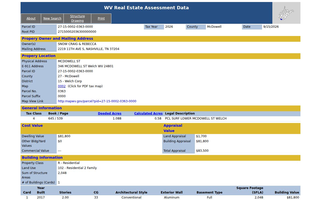
One Welch parcel illustrates how a McDowell County property search works from the street inward. The card for PID 27-15-0002-0363-0000 decodes cleanly. County code 27 comes first, then District 15 Welch Corp, Map 0002, Parcel 0363, suffix 0000. It names two owners. The card also lists a Nashville mailing address, a McDowell Street physical address, and an E-911 address of 346 McDowell Street in Welch. The legal description reads "PCL SURF LOWER MCDOWELL ST WELCH."
The card reports 1.088 deeded acres. Calculated acres come to 0.58. A street clue alone proves little. Pair the PID with book/page 645/539 when asking the McDowell County clerk for the plat or deed. The parcel card below displays the current roll fields for this Welch example. Open the Welch owner and value card.
Take that book/page straight to the McDowell County deed index and compare the recorded instrument itself.
Welch Property Records Across Mailing and E-911 Addresses
This McDowell County card shows how one parcel can carry three different location lines. The owner gets mail in Nashville. The physical address sits on McDowell Street. The E-911 entry gives a numbered Welch location. A mailing city answers where tax correspondence goes. The physical address and E-911 note locate the land and emergency access. For an older Welch home, the address may change over decades. The PID and deed description stay stable.
When a street name or house number looks unfamiliar, search McDowell County property records by owner and PID. Then match the book/page against the legal description. An out-of-state mailing line does not move the parcel outside Welch. Nor does a ZIP code define the corporation boundary.
Requesting Welch Permit and Zoning Records
Welch runs on a strong-mayor form of government, with City Hall, a council, a public works director, and a city attorney. The city offers no online building-permit portal, zoning lookup, code-case search, demolition database, or searchable business-license list. A permit or zoning request therefore goes directly to city staff rather than through a parcel query.
Reach City Hall at 88 Howard Street, Welch, WV 24801, phone 304-436-3113, fax 304-436-2546, or welchwv@mcswv.net. Ask whether the city holds building, demolition, zoning, code, street-renumbering, or public-works files for the address. Include the parcel owner or applicant if known, plus an approximate date. The city publishes no permit fee or retention period.
Welch Property Records and Assessment Values
The same McDowell County card carries the numbers that drive the tax bill. Land appraisal comes in at $1,700. Dwelling appraisal is $81,800. Total appraisal reaches $83,500 for Tax Year 2026. It also describes a 2,048-square-foot two-family structure built in 2017. West Virginia assesses real property at 60 percent of true and actual value. The assessor revalues parcels on a three-year cycle and publishes annual updates.
Read these figures as tax data, not a local price trend. The county publishes no Welch district trend or historic-district overlay. A deed's consideration records one transaction and may not equal current market value. Compare similar properties across tax years. Ask the assessor about class or homestead treatment if the bill is the worry.
Older Welch Property Records and the Clerk's Index
Older McDowell County deed records take patience. The County Clerk's online deed portal sends searches before 1971 to Old Index Books and Non-Indexed Deed Images. Its terms warn that records still in processing may not yet appear. As the county seat, Welch absorbed older place names. An instrument may reference Perryville, English, Coalwood, a river, or a road instead of a modern street. Preserve those terms and the exact legal description while tracing past ownership.
West Virginia Archives materials and FamilySearch microfilm can extend a search into older county books. Ask the Clerk which volume or image series fits the date and instrument type. For a specific deed or chain-of-title question, use the county records rather than assuming a city office keeps a separate deed book. Do not assume a city office keeps a separate deed book.
Welch Property Records: Scope and Limits
A Welch assessment card links an owner of record to a parcel number, legal description, acreage, and tax appraisal. It also lists mailing and physical addresses. The McDowell County Clerk's records show transfers and other recorded instruments. City Hall may hold local administrative files. None of these sources guarantees complete title interests. No source confirms occupancy, a surveyed boundary line, or a current market appraisal. The deed portal cautions that online data stays incomplete while items are processing. The tax roll publishes annually.
Lawful use. Use Welch property records for property history, ownership due diligence and civic research. Do not use owner information to stalk, threaten, harass or harm anyone.