
How a McDowell Property Search Moves Across Records
Start with West Virginia Property Assessment whenever you hold a street address, owner, or tax-map key. Pick McDowell County and open the card that fits. Copy the PID exactly as shown, down to district, map, parcel and suffix. Then carry that PID, the book/page, or the named owner over to the McDowell deed index. Standard, FullText and SoundsLike modes are available there. The portal filters by party role, person or company, date, book/page and instrument type. The tax inquiry and MapWV stay separate. One handles the account; the other shows surface geography.
- Choose McDowell County in the state assessment search and enter the address, owner or parcel information.
- Compare likely results using the physical and E-911 address, legal description and PID.
- Carry the owner name or book/page to the Clerk's deed index and check the instrument itself.
- Use the tax inquiry service for ticket status and MapWV for the parcel's mapped surface context.
- Ask the custodian for an official copy if the online index is incomplete or a certified record is needed.
The assessment search offers the following documented entry choices:
| County | Required to localize the statewide application; choose McDowell County. |
|---|---|
| Owner name | Optional search mode; names may be entered as an individual or entity. |
| Address or street | Optional; physical address and E-911 address may be different. |
| Parcel / map key | Optional; keep county, district, map, parcel and suffix together. |
| Tax year | Optional selector; inspected cards displayed Tax Year 2026. |
The state assessment page lets you pick the county and record type before any search runs. Open the West Virginia assessment search to make those choices directly.
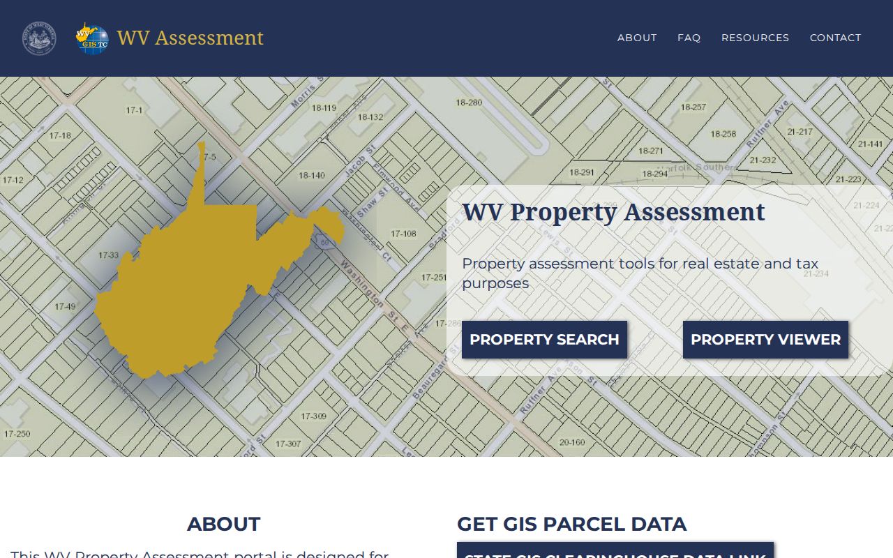
Portal controls appear only after a county is selected, so use the live application for current options.
Choosing a McDowell Property Search Key
Each search key earns its keep at a different stage. A street address feels natural, yet it may be abbreviated, newly assigned, or shown as a rural route. Owner name works well when you trace a portfolio, but names repeat, and holdings often sit inside a trust or company. The full PID is the strongest key once you have it, because it ties the assessment card to a map or tax record. Cross-check two keys before trusting any single result. That caution matters most in narrow valleys and older coalfield communities, where a road and a mailing city may not describe the same place.
| Search key | Useful when | McDowell source | Check beside it |
|---|---|---|---|
| Street or E-911 address | You know where the building is | WV assessment search, then MapWV | Physical address, community, legal description |
| Owner or entity name | You need parcels associated with a name | Assessment roll or Clerk index | Person/company role, alternate spelling, dates |
| PID or map-parcel key | You need an exact parcel match | Assessment, tax map, State Auditor | County 27, district, map, parcel, suffix |
What a McDowell Property Search Result Shows
An assessment card holds far more than an owner name. A McDowell property search result opens into a detailed record. It shows the mailing address, physical address, and E-911 address. County, district, map, parcel number, and suffix sit alongside the book and page reference.
The card also carries the tax class, deeded and calculated acres, and the legal description. Land-use class appears too, plus living area and building-card details. Appraisal figures round it out: land appraisal, dwelling or building appraisal, and a total appraisal. Each field serves its own purpose. The mailing line points to where tax correspondence goes. The E-911 line helps identify a site. The PID carries a durable link. It ties the parcel to county and state property records.
| Owner(s) | The name shown on the published assessment roll, not a guarantee of current title. |
|---|---|
| Physical / mailing address | Site or E-911 location beside where tax notices are mailed; the two may be far apart. |
| PID | County, district, map, parcel and suffix identify the assessment parcel. |
| Appraisal and tax year | Land, building and total appraisal tied to the card's assessment year. |
| Legal description and acreage | Recorded-style description, deeded acres and a separate calculated-area figure. |
| Book/page | A reference to follow in the Clerk index; it is not itself a deed image. |
A search result has limits. It does not prove who lives in the building. It does not confirm every interest has been found, and it cannot place a boundary on the ground. The deed index is a convenience system that warns of documents still in processing, while the state viewer publishes annually. Treat any result as a starting point for confirmation. It is no substitute for the signed instrument, a current title examination, or a field survey.
The official assessment card on the state site displays the owner and address fields described here. View the Welch assessment-card source for the sample record.
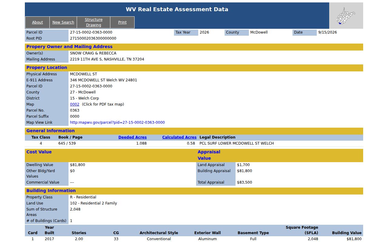
The Welch example shows a common split. The mailing address is in Nashville, while the physical property and E-911 location are in Welch.
Separate Owner Mailing and McDowell Situs
A parcel is not wrong just because the owner mailing address sits far from the land. The Welch sample card lists SNOW CRAIG & REBECCA, a Nashville mailing address, and a physical address of McDowell Street. It also shows E-911 address 346 McDowell Street in Welch. Another parcel in the War corporation district reverses the pattern. That card carries a Welch mailing address and a route-style physical location. A careful property search compares all address fields against the district and the legal description.
For older descriptions, keep the road, creek, mine addition, lot, or community wording. Keep the modern address too. A USPS city label reflects postal routing, not a corporate boundary. Confirm the situs location with the assessor. The plat or GIS map also helps. Do not trust the mailing city alone.
Searching McDowell Names, Estates and Companies
A name search in McDowell County needs a plan. Know which index answers which question. The assessment roll shows where a person stands as owner of record. The deed index is different. There you must separate grantor from grantee, and a person from a company. Spelling is often shaky. The old handwriting can be hard to read. Run the same name in Standard, FullText, and SoundsLike modes before giving up.
Entities need extra care. An LLC, trust, or estate needs its exact name. Search it under the exact vesting name on the deed. Look for the fiduciary or entity as a separate party too. Never assume a trustee, executor, member, or family contact owns the parcel personally. For a registered company, West Virginia's Secretary of State business-entity search supplies public filing information. That filing still cannot prove who benefits from the entity or settle a parcel's title. Probate and guardianship filings live with the County Clerk. Older estate records may call for the archived books or microfilm.
Carry the McDowell Book and Page Forward
A book/page entry on a McDowell tax card is a useful lead. It bridges the assessor to the recorder. Enter the reference in the Clerk portal's book and page controls when they are available, then open the instrument itself and confirm the party names, the instrument type, the date and the legal description. The index may not return a result. Search the grantee name and a date range instead. Treat the number as a lead only; a related image can be incomplete, and a later conveyance may still exist.
Next, set the deed's legal description beside the assessor card and map. A recent transfer may divide a tract. The annual roll can lag behind. Follow the deed chain for title history. For tax payment status, switch to the separate ticket inquiry system instead.
When a McDowell Property Search Is Behind
West Virginia publishes assessment results once a year. The state warns that a recent purchase may not yet appear there. A simple ownership update can wait for that release. Timing rules govern maps too. When a transfer moves a parcel line between July 1 and June 30, assessors must submit revised maps by February 1 of the next calendar year. The viewer says to contact the local assessor if a line stays wrong for two years. An old owner name, a new deed and an old map can therefore coexist for a while without proving any error in the deed.
What should you do when the data disagree? Note the tax year first. Then get the latest deed from the Clerk. Ask the assessor whether an update is pending, and keep both the old and new PIDs if the parcel was split so the tax ticket and map can be traced through the change.
Search McDowell Records by Address, Owner or Parcel
A good McDowell property search rests on three anchors. Use an address to find the roll. A PID keeps the same parcel in view. Use an owner name or a book/page to reach the deed. Any one clue can fail, because an address is incomplete, the owner is a company, or the roll has not been refreshed. Compare two or more fields before accepting a card as the match; that cross-check is the core of a reliable property search.
Sometimes a deed reference turns up without a matching assessor card. Search the Clerk's book and page directly. Then compare its grantor, grantee and legal description with the neighboring assessment entries. A name can produce several instruments. Narrow by date range, by person or company type, and by the kind of instrument. A release or deed of trust is not a new conveyance. Online results can lag too. The portal warns that some records are still in processing, and it sends pre-1971 research to Old Index Books and Non-Indexed Deed Images. Ask the Clerk which path fits your date. Do not conclude the property has no earlier filing.
Addresses in McDowell County need care. Compare the assessor's physical address and E-911 line instead of trusting the mailing address. The Welch sample shows why. It lists a Nashville mailing entry but a McDowell Street site and a more specific Welch E-911 address. A War Corp parcel can carry a Welch mailing city while sitting along S S WV Route 16. These gaps are useful search clues. They do not settle the municipal boundary on their own.
Start with the exact owner spelling on the card. Try that party in the Clerk's property records index. Run it as grantor and as grantee when you follow a chain. Set the person or company controls as fitting. Compare Standard, FullText and SoundsLike results when a name or scan varies. A deed book/page from the card narrows the instrument search, but confirm the deed date, party names and legal description before linking it to the parcel.
Splits deserve their own note. If a parcel was divided, keep both PIDs. Record the deed date beside them. Publication is annual, revised maps for lines changed July 1 through June 30 arrive by the next February 1, and if a line stays wrong after two years call the assessor.
| Search Key | Best For | Where It Works | Watch Out |
|---|---|---|---|
| Address | Identify a specific physical site | Assessment search and MapWV | Route, E-911 and postal labels can differ |
| Owner name | Find parcels or instruments tied to a party | Assessment roll or Clerk index | Variants, entities and role selection matter |
| Parcel number | Match one assessment parcel precisely | Assessment, GIS and tax-map references | Keep district, map, parcel and suffix intact |
Not a title search. A McDowell search shows records in the systems checked; it does not prove that all interests or later unindexed documents have been found. Use a title professional for an ownership conclusion.