
What the McDowell Current Owner Card Shows
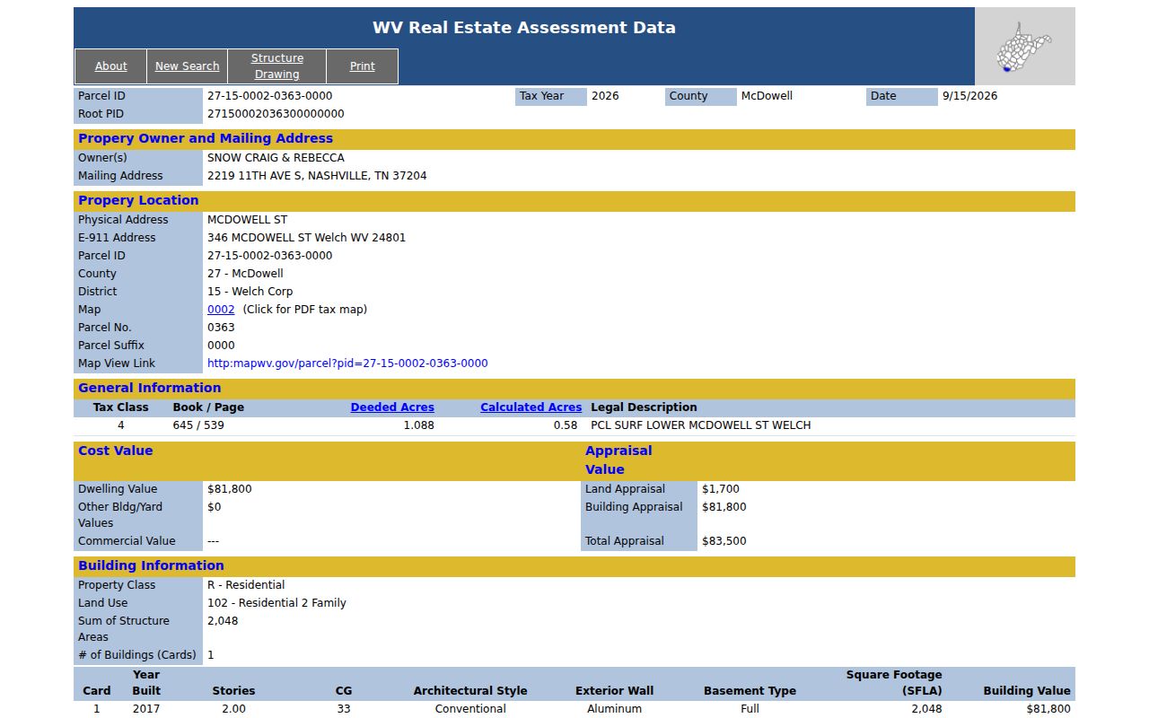
A West Virginia assessment card names the owner carried on the published roll. It also ties that name to a parcel. The example card from Welch showed plenty. Owner names appeared alongside an out-of-state mailing address and a physical location on McDowell Street. A sharper E-911 address was there too. So were tax class, book/page, and the legal description. Land and building values were listed separately. With those fields, a property search can test identity and location. It does this without pretending the card is a deed. The tax year matters too. The roll is annual. A current owner lookup can still display the prior year's owner.
| Owner(s) | Name or entity shown on the published assessment roll. |
|---|---|
| Vesting clue | Read the deed to see whether title is held jointly, by a trust, estate, company or public body. |
| Mailing address | Where tax correspondence is directed; it may be out of county or state. |
| Physical and E-911 | Site location fields that may be more specific than a community or route. |
| Book/page | Starting reference for finding the recorded instrument. |
| Tax year | Publication year to compare with the closing and assessment history. |
An owner of record need not occupy the place. That surprises some searchers. A mailing address shows where assessment notices and tax bills are sent. Physical and E-911 lines locate the parcel itself. Trusts and government bodies can hold title, and an owner may live in another state. None of these fields proves who is inside the building today. Location is separate from ownership. For the Welch example, view the McDowell assessment card, which displays the owner, mailing, and site fields together.
Check book/page and deed before trusting the owner field.
How Current the McDowell Owner Roll Is
West Virginia publishes assessment data once a year. A recent purchase may not appear yet. The Clerk can record a deed before the new name ever reaches the state assessment card. The online deed portal warns about processing too. Documents still moving through intake may not sit in its index. So the two systems update on different clocks. Compare them by recording date and tax year.
Parcel lines complicate the timing. When a transfer redraws boundaries, the assessor's map follows its own schedule. Revisions for changes arising between July 1 and June 30 are due by February 1 of the next calendar year. The state viewer advises contacting the local assessor if a map stays wrong for two years. Knowing this timeline separates ordinary publication lag from a genuine data problem.
Confirm the McDowell Current Owner in a Deed
Start with the assessment card. It suggests a likely grantee and parcel. Then verify that name in a recorded instrument at the County Clerk's office. Search the owner as grantee and open the probable acquisition deed. Party names, the recording reference, and the legal description should all match the assessor card. Businesses, estates, and trusts need a search under their exact legal name. If the portal index looks incomplete, ask the Clerk. Documents in processing may not be visible online.
- Open the McDowell assessment card and record owner(s), tax year, PID and book/page.
- Search the deed index for the owner as grantee and inspect the latest matching conveyance.
- Compare the deed's legal description and vesting language with the parcel card.
- If an entity is named, check its public Secretary of State filing without treating an agent as the owner.
- Ask the assessor about a roll update if the deed is newer than the assessment entry.
- Owner of record
- The party named on the published county assessment roll.
- Vesting
- The way an instrument holds title, such as joint, trust, estate or entity ownership.
- Registered agent
- A company contact shown in a state filing, not necessarily the landowner.
Recent McDowell Closings and Roll Changes
An old-looking owner field deserves a quick test. Compare tax year against deed date. Annual publication can leave a finished sale off the state result for a while. Changed parcel boundaries take longer still, since map revisions trail ownership updates. Keep the deed reference handy. Also keep the prior and new PID if known, and the date the assessment page was viewed. Ask the Clerk whether the document has been indexed. Ask the assessor whether an owner or map update awaits release.
A tax ticket's taxpayer name is not a title record. A bill can stay tied to the account information available for its billing cycle. Check both sources. The County Clerk deed and the assessor roll together establish the owner of record.
A McDowell Mailing Address Does Not Show Occupancy
The Welch example shows why the mailing line means so little about occupancy. Its owner mailing address sits in Nashville, Tennessee. The physical and E-911 addresses both point to Welch. So the out-of-state mailing entry simply reflects where notices go. It says nothing about who lives in the building. A War Corp school parcel behaves the same way. It carries a Welch mailing address and a route-style physical location in District 14.
Use the mailing line only for legitimate property correspondence. To place the land itself, match physical and E-911 data. Pair that with the full PID, legal description, and map. ZIP and city labels describe postal delivery, not municipal boundaries.
Trusts, Estates and Public Owners in McDowell
Ownership takes many shapes in McDowell County records. The owner can be one person, several co-owners, a trustee, an executor, an estate, an LLC, or a public entity. The Welch card lists two individual names. The War district school example lists the McDowell County Board of Education across multiple building cards. Different shapes need different checks. Read the vesting clause in the latest instrument and compare it with the owner field. Do not infer a person's rights from an entity's mailing contact.
Entities file with the Secretary of State. Those filings can surface an entity's public record. Probate and guardianship records may add context for an estate transfer. Neither one replaces the deed that conveys the real property.
Match the McDowell PID to the Current Owner
A McDowell County parcel number opens with county code 27. The rest carries district, map, parcel, and suffix. Keep every piece of it. One owner can hold several nearby parcels. An address alone may point to the wrong tract. The assessor card's book and page should describe the same land as the deed you are checking. The legal description and the PID should too. Where a recent split occurred, note both the old and new parcel numbers. Then confirm which identifier the current tax year carries.
The owner of record is settled by a matching deed and tax roll entry. A map polygon or postal city label cannot answer it. The assessor card and the latest filed instrument may disagree. Ask the assessor to review the roll. The Clerk can verify the recorded deed itself.
Contacting a McDowell Property Owner
A mailing address on a McDowell County assessment record exists for official notices. It can still give you a lawful route for property correspondence. Use it respectfully. The current owner field does not reveal private contact details beyond that entry. West Virginia's Address Confidentiality Program gives participants a substitute address. Never treat a public mailing line as a clue to a protected person's home. Never treat it as a window into their routine.
Before mailing any letter, confirm the address belongs to the right parcel. Compare the PID, the physical address, and the latest deed. One owner may hold multiple McDowell parcels. A single tax mailing location can even serve several accounts. If your aim is to fix an assessment or request a record, go through the assessor or County Clerk. Do that instead of guessing at a personal channel. Keep the letter to the property matter at hand. A public assessment entry is not consent to unrelated contact.
Lawful use. A McDowell current owner lookup supports property due diligence and civic research. Do not use names or mailing addresses to stalk, threaten, harass or harm anyone.